Iliff Commons
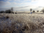 The native prairie and woods of the Iliff Commons have never been developed, unless you count numerous squatters during the Bleeding Kansas era before the Civil War-- who built dugouts or rude log cabins only to have them burned down by soldiers from Ft. Leavenworth! The Commons was a portion of the Kaw Half-breed Reserve No. 7, deeded to Marie Gonvil by a treaty in 1825. Marie was the daughter of Kaw Chief White Plume and the wife of Pierre Gonvil,, a French trader who settled in the area. The 23 Reserves, which stretched along the north bank of the Kaw River from Topeka to Lecompton, were made an “unalienable” gift to 23 mixed-blood descendants of White Plume by the U.S. government.
 That did not prevent the owners from selling them to white settlers during the territorial period, often multiple times. Andrew Reeder, the first territorial governor, was sacked by President Franklin Pierce in part for speculating in these lands, which were valuable for their timber. Timber was scarce south of the river, but abundant to the north. Because the deeds were unalienable, sales inevitably reverted to the original native owners; in fact, clear title could not be obtained until the 1980s, when Topeka judge Franklin Theis finally ruled that enough time had passed to abrogate the original treaty.
 Dr. and Mrs. Iliff bought 80 acres from a developer to preserve the land in its native state. The prairie, after years serving as neglected pasture, is gradually being restored by burning and reinstitution of native species. Several miles of trails have been carved through the grass and woods to serve as walking, running, cross-country skiing, and mountain biking courses.
 Wildlife includes deer, wild turkey, fox, bobcat, and the usual assortment of common critters. Red-tailed hawks and bald eagles patrol the prairie. Visitors are welcome from dawn to dusk every day of the year. Parking is available inside the entrance on the south side of NE 31st just east of Kincaid. Access to 31st is from Happy Hollow on the west, and K-4 on the east. Please respect the land, and do not take motorized vehicles past the barrier posts.
Founders Cabin
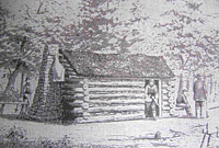
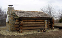 As a part of Topeka’s 2004 sesquicentennial celebration, Eagle Scout candidate Joshua Layne-- a student of Dorothy Iliff at State Street Elementary School-- led volunteers from Troop 1 of Oakland United Methodist Church in the construction of a replica of Topeka’s first dwelling.
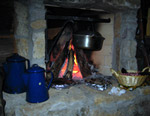
On December 5th, 1854, nine men residing in this primitive 12 by 14 foot cabin signed the agreement establishing the Topeka Association. Among them were Cyrus K Holliday, the founder of the Atchison, Topeka, and Santa Fe railroad, and Charles Robinson, a future governor. The cabin is constructed of used telephone poles rather than scrub trees, roofed with cedar shakes instead of sod, and the chimney is stone and mortar in place of rocks, sticks, and mud. Neverthless, visitors and overnighters will get an authentic touch of what our forefathers experienced. Holliday claimed that up to 21 people spent the night at one time in the cabin during the winter of 1854-55-- before a spark from the chimney caught the roof on fire and forced its inhabitants to dwell in tents until spring arrived!
 Visitors are welcome to park in the pasture at the entrance of the Commons and walk roughly a mile to the cabin through native prairie and woods. Follow the signs along the mowed path or jot down these specific directions:
Starting at the Iliff Commons monument, follow the path heading south. At junction 1, bear left. When you see the cabin down the hill to your right, you can cut across the prairie if you want to risk critter holes and chiggers. Otherwise, follow the path and at junctions 2 and 3, bear right. At junction 4, bear left. The cabin will appear on your left.
 No motorized vehicles are allowed, but mountain bikers are also welcome to follow the service trail/bike path to the same location.
The entrance to the Commons is a chipped driveway 50 feet east of the intersection on the south side of 31st Street